- ALL COMPUTER, ELECTRONICS AND MECHANICAL COURSES AVAILABLE…. PROJECT GUIDANCE SINCE 2004. FOR FURTHER DETAILS CALL 9443117328
Projects > ELECTRONICS > 2017 > IEEE > DIGITAL IMAGE PROCESSING
Object detection is one of the mandatory steps in transferring imagery data into land cover information. Deep networks in machine learning have shown capabilities in automatic object detection and generated promising results. The patch based Deep Neural Network (DNN) is one of the architectures that is designed for a pixel based object detection in aerial images. The network was designed for the images with 1.2 m spatial resolution, thus, it was unable to generate promising results for a large ortho photo aerial data set obtained over Fredericton city with 0.15 m spatial resolution. In this paper, the patched-based deep neural network is further improved for detecting roads in Fredericton data set. The network is redesigned based on our data and then, trained and applied to the data set.
Optimization Method.
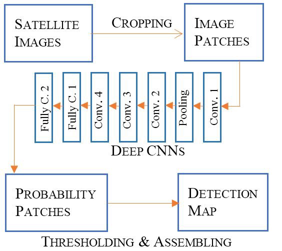
In this paper, a patched-based deep neural network is used for detecting roads in city map update. The labels for this data set is generated by using the road center vector for the area. The architecture of the network is improved and redesigned for our data set, due to the extreme difference in the spatial resolution of the input images with previous data set. The designed network has six layers, four convolutional and two fully connected. Only the first convolution layer is followed by pooling layer to prevent misplacement of the object’s position. The patch-based deep network increased the quality of the detected objects. First, the proposed architecture fits the large data set very well. Secondly, based on the evaluation, it is shown that the detection model is capable of extracting the road net with higher accuracy, although there are some noises in the labels due to the misregistration and target generation process.
BLOCK DIAGRAM