- ALL COMPUTER, ELECTRONICS AND MECHANICAL COURSES AVAILABLE…. PROJECT GUIDANCE SINCE 2004. FOR FURTHER DETAILS CALL 9443117328
Projects > ELECTRONICS > 2019 > IEEE > DIGITAL IMAGE PROCESSING
Polarimetric response is strongly target orientation dependent. The observed polarimetric matrices from the same target with different orientations can be quite different. The existence of target scattering orientation diversity contains rich information, and leveraging information of target scattering orientation diversity may help to reveal polarimetric properties of different land cover types. In this work, a robust land cover feature descriptor, dynamic fractal texture, is introduced to capture the stochastic self-similarities of land cover scattering responses in both spatial and rotation domains. We extend the polarimetric matrix to the rotation domain by polarimetric basis transformation. Varying polarization orientation angle (POA) or ellipticity angle (EA), polarimetric responses of land cover under a series of orientations can be obtained. Then, the dynamic fractal texture is formulated by serializing received responses as a polarimetric synthetic-aperture radar (PolSAR) image sequence. Finally, the proposed features are combined with random forest (RF)/ support vector machine (SVM) classifier to produce the classification maps on real PolSAR data. Experiment results show that dynamic fractal texture has an advantage in indicating rotation domain information. The proposed method has superior performance in land cover classification and yields accurate classification results.
Uniform polarimetric matrix rotation theory and a visualization and characterization tool of polarimetric coherence pattern
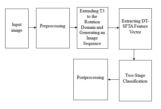
The proposed classification scheme is mainly organized by three parts, including: 1) extending polarimetric matrix to the rotation domain and generating an image sequence; 2) formulating dynamic fractal texture to present the orientation diversity information; and 3) a two-stage classification. Extending coherency matrix T3 to the rotation domain by polarimetric basis transformation, polarimetric responses of land cover under a series of orientations can be obtained, and the generated image sequence contains information of target scattering orientation diversity. Extract DT-SFTA feature vector for each pixel in the XY plane. The SFTA features of three selected grayscale images are extracted, respectively, and concatenated to form the feature vector. In Two-Stage Classification, random forest (RF) and support vector machine (SVM) are adopted in this work. Both RF and SVM are commonly used classifiers with a wide range of applications, and both of them have the ability to process input samples with high dimensional features with excellent accuracy.
BLOCK DIAGRAM