- ALL COMPUTER, ELECTRONICS AND MECHANICAL COURSES AVAILABLE…. PROJECT GUIDANCE SINCE 2004. FOR FURTHER DETAILS CALL 9443117328
Projects > ELECTRONICS > 2017 > IEEE > DIGITAL IMAGE PROCESSING
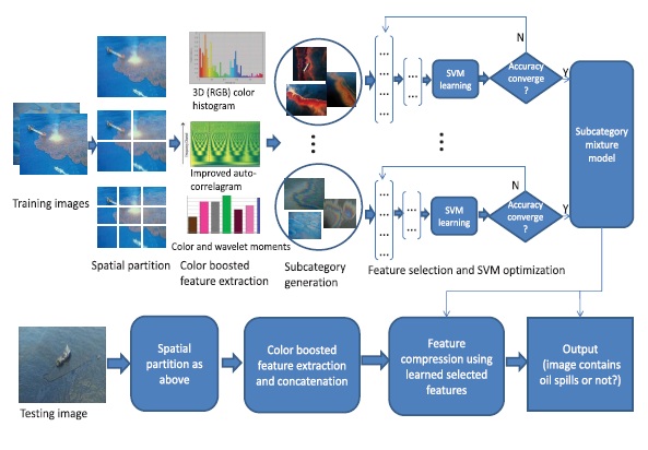
Oil spill inspection is critical to the marine and coastal ecosystems, and has been widely studied by various remote sensing technologies, such as synthetic aperture radar and hyperspectral. To improve the temporal resolution and the inspection flexibility, we propose a novel aerial image-based system that can find oil spills timely from images captured using onboard optical cameras installed in unmanned aerial vehicle or airplanes. In particular, a subcategory-aware feature selection (FS) and support vector machine (SVM) joint optimization technique is proposed to learn a discriminative model that can tell the existence of oil spills within an optical image of the marine surface. A set of color-based features is first extracted and concatenated together to characterize the oil spill incidence in an image, where a new color auto correlogram is designed, which can better describe each color’s spatial distribution in an image. Furthermore, subcategory-aware joint FS and SVM optimization technique is designed, which is capable of generating the optimal feature subset and SVM component models.
Artificial Neural Networks, K-Means Clustering Algorithm.
We propose an aerial image-based oil spill inspection technique. The aerial imaging platform, such as UAV equipped with optical camera, first captures an aerial image of the marine surface and sends it to a remote server via wireless network. The server then performs image analysis to give a decision on whether the captured image contains oil spills or not. To the best of our knowledge, this is the first work that uses aerial optical images of the marine surface for automatic oil spill inspection. Aerial image-based oil spill inspection has a number of advantages. First, aerial images are captured close to the sea surface and contain more details of oil spills. Second, aerial images captured by UAV platforms provide better temporal information, which can serve as another clue for image analysis. Third, aerial images of oil spills can be captured from different viewpoints by optical cameras, which provide better characterization of the incidence. Fourth, aerial images are more cost effective and affordable than satellite based SAR or hyperspectral images. The proposed technique is based on two observations. First, the major differences between oil spills and sea water images lie in the color composites and their spatial distributions. Second, the oil spill images often present large intraclass variations due to different appearances of oil colors, shapes, and contextual surroundings. With these two observations, we propose a subcategory-aware feature selection (FS) and support vector machine (SVM) optimization technique that has two major contributions.
BLOCK DIAGRAM